

The Chiapas State Civil Protection Secretariat has a total of 12 active State Special Civil Protection Programs in 2026, covering each of the main disruptive events and risk seasons in the Chiapas calendar. The complete package is available to the public on the official website proteccioncivil.chiapas.gob.mx, with descriptions, objectives, and downloadable files for public consultation.
The program framework established by the Chiapas State Institute for Comprehensive Disaster Risk Management (IGIRD) is based on a comprehensive risk management approach and is coordinated by the three levels of government: federal, state, and municipal. The goal is for each identified risk to have a specific response protocol, with clearly differentiated actions for prevention, preparedness, response, and recovery.
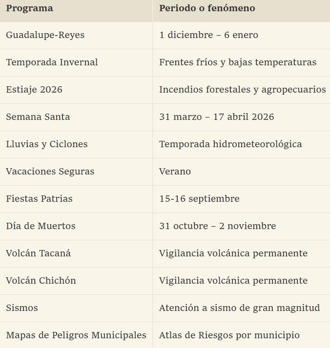
The operational programs cover seasons and events. In chronological order, the calendar year begins with the Guadalupe-Reyes program, which runs from December 1st to January 6th and focuses on large religious events and end-of-year festivities. This is followed by the Winter Season, characterized by cold fronts and low temperatures; the Dry Season, with its associated forest fires and agricultural burning; Holy Week, which in 2016 ran from March 31st to April 17th; the Rainy and Cyclone Season, covering June-November; the Safe Summer Vacation Program; the Independence Day celebrations on September 15th and 16th; and the Day of the Dead, from October 31st to November 2nd.
In addition to these seasonal programs, there are three permanent plans for high-impact geological phenomena in Chiapas. The first is the Tacaná Volcano Special Program, located on the border with Guatemala; the second is the Chichón Volcano Special Program, which had its last major eruption in 1982; And the third is the Special Earthquake Program, designed to respond to a large-scale event, considering that Chiapas sits on the convergence of three tectonic plates: Cocos, North American and Caribbean.
The portfolio is complemented by the Municipal Hazard Map, a Google Drive repository operated by IGIRD that integrates geospatial information on disruptive phenomena to which each community is exposed. It is free to download and allows Internal Civil Protection Units, schools, parishes, businesses, and civil associations to develop their own plans aligned with the State Risk Atlas. The Multi-Alert System and the network of portable weather stations that support daily operations are also available.
For 2026, the operational priority of Chiapas Civil Protection is to activate each program in stages as the calendar progresses. Currently, the Dry Season program and the preventive phase of the Rain and Cyclone program are simultaneously active, while the Holy Week and Winter Holiday operations have already concluded. The main office is located in Emiliano Zapata km. 1.9, Tuxtla Gutiérrez, with telephone numbers 961 615 5178 and 961 615 4712. The official networks are @pcivilchiapas on Twitter, Facebook, Instagram and TikTok
")
Source: alertachiapas


